geoWidgets Activity Packs

9 New Activities Available in geoWidgets Conversion Activity Pack

We are always looking what improvements can be made to our geoWidgets Activity Packs. Our Fall release of geoWidgets Conversion Activity Pack met the needs of the project we were working on. We wanted to add more functionality and its finally here!

Have you wanted to import and export Shapefiles, GPX, KML/KMZ, GPS, and GeoJSON from your Web AppBuilder and Geocortex Web GIS applications? Now you can with geoWidgets Conversion Activity Pack whether you use the SaaS or On-Premise version of Geocortex Workflow!

What is geoWidgets Conversion Activity Pack?

geoWidgets Conversion Activity Pack provides you 16 Workflow Activities to import and export common GIS data formats (SHP, KML/KMZ, GPX, GeoJSON) and spreadsheets (XLSX, XLS, ODS, CSV, TXT) in Web AppBuilder for ArcGIS® and Geocortex® Web GIS applications. All of these activities are JavaScript and run client-side so you can use them in both the SaaS and On-Premise version of Geocortex Workflow 5.

Don’t let your stock Web GIS be a barrier to utilizing all your data assets throughout your organization. Provide your users the ability to not only display these file types in your web mapping application but use Geocortex Workflow to manipulate the data into virtually

What New Activities were released?

New Import Activities

Shapefile to Features

Shapefile to Features converts a zipped Shapefile into an ESRI FeatureSet for all vector data types (Points, Lines, Polygons).

KML/KMZ to Features

KML/KMZ to Features converts an KML or KMZ file into an ESRI FeatureSet for all vector data types (Points, Lines, Polygons).

GPX to Features

GPX to Features converts a GPX file into an ESRI FeatureSet for all vector data types (Points, Lines).

GeoJSON to Features

GeoJSON to Features converts a GeoJSON string into an ESRI FeatureSet for all vector data types (Points, Lines, Polygons).

GeoJSON to Features

GeoJSON to Features converts a GeoJSON string into an ESRI FeatureSet for all vector data types (Points, Lines, Polygons).

New Export Activities

Features to GeoJSON

Features to GeoJSON converts an Esri FeatureSet to a GeoJSON file object.

Features to GPX

Features to GPX converts an Esri FeatureSet to a GPX file object.

New File Utility Activities

Zip File – Zip File converts an array of geoWidgets File Object[] into a ZIP archive.

Unzip File – Unzip File will decompress a zip archive into a geoWidgets File Object.

geoWidgets File Object – A geoWidgets File Object is a constructor to simplify, parse, and manage File Object creation.

Why use geoWidgets Conversion Activity Pack?

  • Support for both SaaS and On-Premise versions of Geocortex Workflow.
  • Faster file processing because it is performed in your user’s browser.
  • Increase security by preprocessing your user’s files in their browser. You decide what is sent to your server.
  • Free up server resources by distributing processing to your clients.
  • Client-side activities work offline
  • Well documented with examples of each activity to get you started right away
  • Free!

How do I get the geoWidgets Conversion Activity Pack?

If you already use geoWidgets Conversion Activity Pack, they will be available to you. If you want to use our Activity Pack, follow these instructions:

In your ArcGIS Online organization or Portal for ArcGIS:

  1. Click Add Item > Add an Application
  2. Fill out the Add an Application dialog with the following:
    1. TypeWeb Mapping
    2. Purpose and API: Use the defaults (“Ready to Use” and “JavaScript“, respectively)
    3. URLhttps://cdn.geowidgets.io/activitypacks/conversion/current/
    4. TitlegeoWidgets Conversion Activity Pack
    5. Categories: Optional. Does not affect the item.
    6. Tags: You must add “geocortex-workflow-activity-pack” as a tag. You can add others but “geocortex-workflow-activity-pack” is how Geocortex Workflow finds the Activity Packs within your organization.
    7. The completed form should look like this:
  3. Click Add Item to create the new item.
  4. Once created, click Share. You can share this with your entire organization or with the specific group use Geocortex Workflow. This is up to your internal security structure.

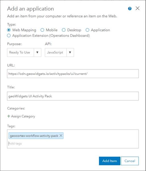
For direct notification of updates, please sign up on ArcGIS Marketplace.

Digital Data Services, Inc., is a GIS consulting firm that utilizes the power of the Esri product suite to provide state-of-the-art desktop and web GIS solutions since 1998. Our staff provides implementation and customization solutions for Esri web GIS and Geocortex products. If you need assistance, we are here to help solve your web GIS challenges. 

Esri Partner Network
Geocortex Business Partner
ArcGIS Marketplace